News
Titletown District health clinic wins top honor among large projects constructed over $10 million
Bellin Health Titletown Sports Medicine & Orthopedics received a 2018 Excellence in Structural Engineering Award, in the projects category of $10 million or greater in construction costs, from the Structural Engineers Association of Wisconsin (SEA-WI).
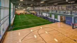 The structural design responded to the two-story building’s highly restrictive aesthetic requirements that a prominent facility in a high-visibility location requires while also meeting technical and functional requirements for clinic staff and patients. raSmith’s engineers applied an innovative and cost-saving floating floor system in conjunction with an isolated ceiling system that was specified for the project. These systems mitigate second-floor vibration from various physical activities so the first-floor exam rooms and offices remain relatively quiet.
raSmith’s structural engineers also applied ingenuity when faced with the site’s poor soils and a water table that was higher than the building’s partial basement. They designed an encapsulated concrete “bathtub” to keep the lower level dry and an auger-cast pile system to provide steady support to combat the poor soils. These efficient solutions provided an overall cost savings, plus the pile system assisted in minimizing the construction impact on the adjacent residential housing site.
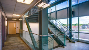 The Bellin Health clinic serves Green Bay Packers players as well as the general public. The two-story building features interior spaces that mimic Lambeau Field. The project celebrated a grand opening in July 2017.